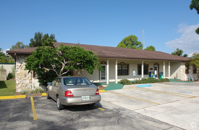
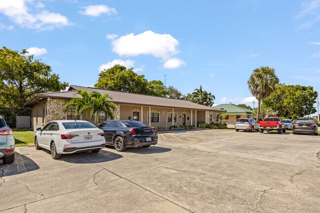
Property Record
2255 N Courtenay Pky, Merritt Island, FL 32953

NEARBY LISTINGS FOR SALE OR LEASE
Property Detail
2255 N Courtenay Pky
24-36-14-00-00503.1-0000.00
Azalea Place Condominium
Officecondo
AZALEA PLACE CONDO PHASE I UNIT 1 AZALEA PLACE CONDO PHASE I AS DESC IN ORB 2421 PG 1434 AND ALL AMENDMENTS THERETO.
X
Brevard
12009C0340H
Florida
2024
0.10 AC
2025
Brevard County
069907
Orlando
818 SF
Palm Bay-Melbourne-Titusville, FL
DEMOGRAPHICS near 2255 N Courtenay Pky
1 Mile
3 Mile
5 Mile
2024 Total Population
5,976
30,017
72,812
2029 Population
6,449
32,500
79,573
Pop Growth 2024-2029
+ 7.91%
+ 8.27%
+ 9.29%
Average Age
47
46
44
2024 Total Households
2,463
13,064
31,257
HH Growth 2024-2029
+ 7.63%
+ 8.05%
+ 9.15%
Median Household Inc
$81,463
$72,813
$58,860
Avg Household Size
2.30
2.20
2.30
2024 Avg HH Vehicles
2.00
2.00
2.00
Median Home Value
$363,461
$345,244
$288,796
Median Year Built
1982
1973
1976
Nearby Places
Map Layers
Map Styles
 Street
 Aerial
- Restaurants
- Banks
- Shops
- Fitness
- Groceries
PUBLIC TRANSPORTATION
AIRPORT
Melbourne Orlando International
DRIVE
WALK
Distance
Melbourne Orlando International
47 min
28.8 mi
Freight Ports
Port Canaveral
DRIVE
WALK
Distance
Port Canaveral
10 min
6.4 mi
Nearby Properties
Address
Land Use
TOTAL SIZE
Lot Size
Zoning
Address
Land Use
TOTAL SIZE
Lot Size
Zoning
16,433 SF
89.08 AC
GML
Address
Land Use
TOTAL SIZE
Lot Size
Zoning
256,094 SF
37.37 AC
BU1
Address
Land Use
TOTAL SIZE
Lot Size
Zoning
211,483 SF
14.46 AC
BU2
Address
Land Use
TOTAL SIZE
Lot Size
Zoning
313,612 SF
11.91 AC
BU1
Address
Land Use
TOTAL SIZE
Lot Size
Zoning
180,092 SF
38.20 AC
PIP
Address
Land Use
TOTAL SIZE
Lot Size
Zoning
212,232 SF
20.80 AC
RU215
Address
Land Use
TOTAL SIZE
Lot Size
Zoning
153,136 SF
8.65 AC
RU215
Address
Land Use
TOTAL SIZE
Lot Size
Zoning
105,278 SF
14.75 AC
AU
Address
Land Use
TOTAL SIZE
Lot Size
Zoning
211,753 SF
25.16 AC
CG
Address
Land Use
TOTAL SIZE
Lot Size
Zoning
262,753 SF
24.35 AC
PIP
Address
Land Use
TOTAL SIZE
Lot Size
Zoning
140,113 SF
25 AC
GU
Address
Land Use
TOTAL SIZE
Lot Size
Zoning
212,534 SF
14.50 AC
Address
Land Use
TOTAL SIZE
Lot Size
Zoning
6,481 SF
22.73 AC
PIP
Address
Land Use
TOTAL SIZE
Lot Size
Zoning
67,595 SF
6.62 AC
Address
Land Use
TOTAL SIZE
Lot Size
Zoning
120,495 SF
3.86 AC
PUD
Address
Land Use
TOTAL SIZE
Lot Size
Zoning
98,877 SF
7.86 AC
BU2
Address
Land Use
TOTAL SIZE
Lot Size
Zoning
Address
Land Use
TOTAL SIZE
Lot Size
Zoning
75,552 SF
9.95 AC
PUD
Address
Land Use
TOTAL SIZE
Lot Size
Zoning
89,408 SF
18.50 AC
GU
Address
Land Use
TOTAL SIZE
Lot Size
Zoning
101,494 SF
5.81 AC
CC
Address
Land Use
TOTAL SIZE
Lot Size
Zoning
96,814 SF
8.89 AC
RU215
Address
Land Use
TOTAL SIZE
Lot Size
Zoning
70,834 SF
15.33 AC
INL
Address
Land Use
TOTAL SIZE
Lot Size
Zoning
84,747 SF
8.57 AC
BU2
Address
Land Use
TOTAL SIZE
Lot Size
Zoning
130,361 SF
12.77 AC
BU1
Address
Land Use
TOTAL SIZE
Lot Size
Zoning
83,650 SF
25.65 AC
AU
Address
Land Use
TOTAL SIZE
Lot Size
Zoning
97,920 SF
6.08 AC
RU215
Address
Land Use
TOTAL SIZE
Lot Size
Zoning
68,218 SF
9.07 AC
BU1
Address
Land Use
TOTAL SIZE
Lot Size
Zoning
79,845 SF
8.47 AC
RU230
Address
Land Use
TOTAL SIZE
Lot Size
Zoning
61,207 SF
16.03 AC
GU
Address
Land Use
TOTAL SIZE
Lot Size
Zoning
112,440 SF
22.08 AC
BU1
The World's #1 Commercial Real Estate Marketplace
Connect with us
© 2025 CoStar Group
The information above has been obtained from sources believed reliable. While we do not doubt its accuracy we have not verified it and make no guarantee, warranty or representation about it. It is your responsibility to independently confirm its accuracy and completeness. Any projections, opinions, assumptions, or estimates used are for example only and do not represent the current or future performance of the property. The value of this transaction to you depends on tax and other factors which should be evaluated by your tax, financial, and legal advisors. You and your advisors should conduct a careful, independent investigation of the property to determine to your satisfaction the suitability of the property for your needs.